


The National Oceanic and Atmospheric Administration (NOAA) reported earlier this month its most current projected chances of La Niña forming for winter 2024-25.
Here is what meteorologists found.
According to NOAA, the August ENSO outlook said ENSO-Neutral conditions remained across the Pacific, but are moving slowly to La Niña conditions with a 66% chance the phenomenon forms through autumn.
These conditions are favored by enhancing cooler waters currently off the Ecuadorian coast as the Northern Hemisphere approaches autumn.
The weather agency also said there is now a 74% chance of La Niña forming in the same equatorial waters during the November-January time period.

A deep pool of water is building in the Pacific Ocean off the coast of Ecuador, leaning forecasters towards a La Niña forming for winter 2024-25.
"While sea surface temperatures are currently perfectly cromulent (acceptable), below-average water temperatures in the subsurface (the surface to 300 meters below the surface) of the tropical Pacific Ocean strengthened in the past month, expanding across more of the central and eastern Pacific Ocean," Office of Communications staffer with NOAA Tom DiLiberto said.
"These cooler-than-average waters will be one of the driving forces behind any La Niña that forms later this year."

Line graph showing observed and predicted temperatures (black line) in the key ENSO-monitoring region of the tropical Pacific from winter 2023-24 though winter 2024-25. The gray shading shows the range temperatures predicted by individual models that are part of the North American Multi Model Ensemble (NMME, for short). Most of the shading appears below the dashed blue line by the fall, meaning most models predict that temperature in the Niño-3.4 region of the tropical Pacific will be cooler than average by at least 0.5 degrees Celsius (0.9 degrees Fahrenheit) — the La Niña threshold. NOAA Climate.gov image, based on data provided by Climate Prediction Center.
La Niña is a ocean-atmosphere climate phenomenon where the average sea surface temperatures in the Niño-3.4 region of the Pacific Ocean are at least 0.5 Celsius cooler than average in the preceding month.
Following NOAA forecast charts, winter 2024-25 is leaning toward a weak La Niña event, with sea surface temperatures hovering from -0.5 to -0.9 degrees Celsius cooler.
La Niñas are considered strong when the sea surface temperature anomalies are -1.5 Celsius or colder, and considered moderate when they're between -1 to -1.4 Celsius colder.
DiLiberto said the climate models NOAA uses to forecast the La Niña outlook suggest a weaker and delayed formation of La Niña in 2024 than first hinted at in spring.
"In May and June, the models forecasted a start during summer," DiLiberto said. "But the most recent forecasts pinpoint early fall as the most likely start time. Regardless, the overall model consensus remains that La Niña will likely form this year and last through the upcoming winter."
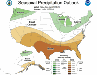
The National Weather Service's seasonal three-month precipitation forecast shows below average precipitation to fall across much of the southern United States, including Colorado, with as high as a 40-50% chance of less-than average precipitation to fall from November to January in southern Colorado.

Seasonal precipitation outlook for November to January heading into winter 2024-25.
Conjunctively, the NWS seasonal three-month temperature forecast shows above-average temperatures across much of the same area, including Colorado with as much as a 40-50% of above-average temperatures from November to January in southern Colorado.

Seasonal temperature outlook for November to January heading into winter 2024-25.
Generally speaking, northern Colorado benefits the most during La Niña winters, where southern Colorado benefits the most during El Niño winters.
However, each winter's weather can and will vary, with actual precipitation and temperatures known more accurately as particular days become closer in real time.
Since 1990, six winters have been classified as weak La Niñas, with the most recent event in the of winter 2022-23.